acreage is a weak substitute for character
Acreage is easy to compare. It gives the buyer a number. It allows sorting, filtering, and quick market orientation. But acreage is also a blunt measure.
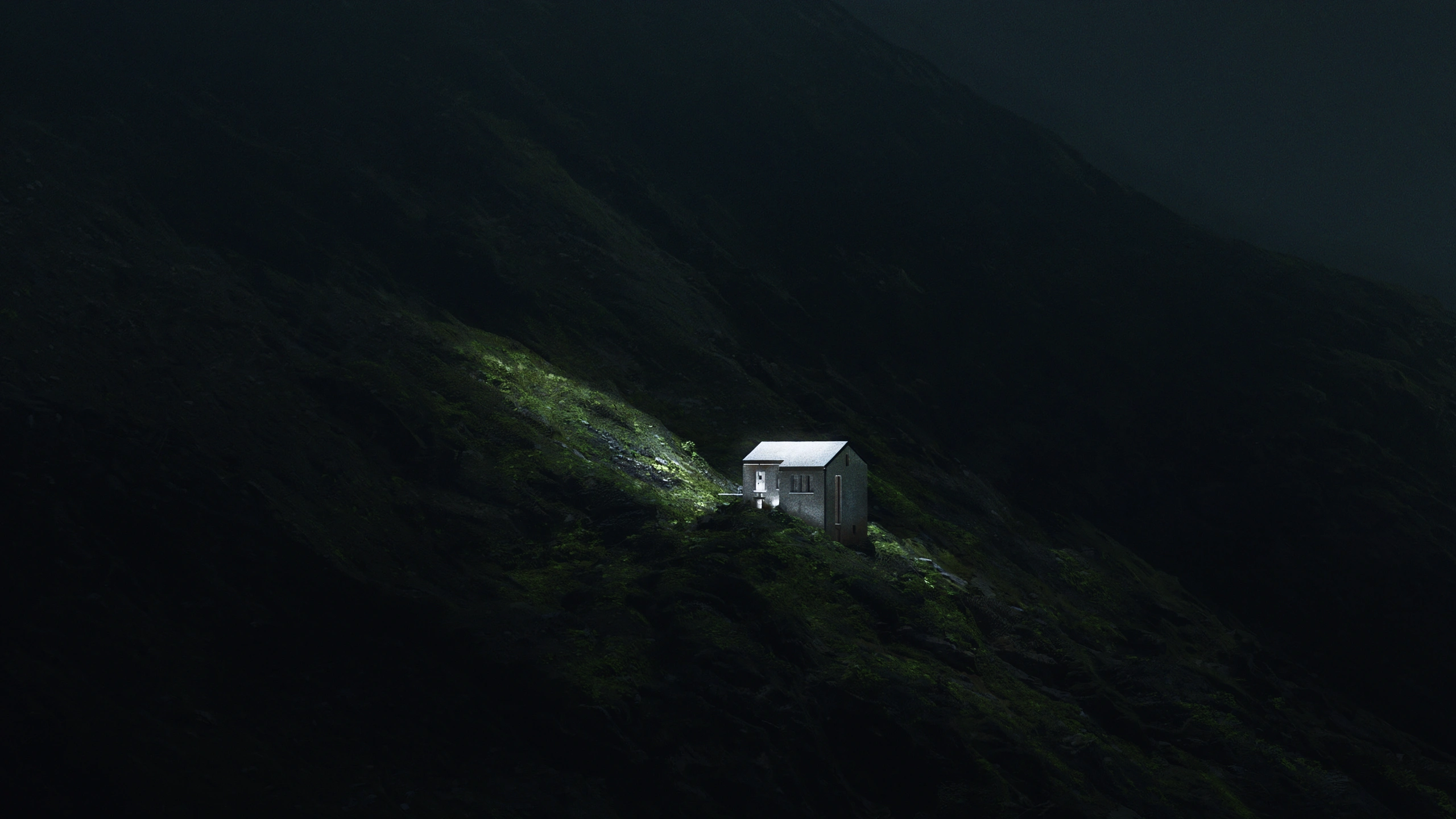
A hundred acres of exposed, visually indifferent land is not the same as a hundred acres shaped by ridgelines, water, tree cover, open meadows, protected views, usable benches, or a rare relationship to surrounding landscape. Two parcels can be similar in size and still belong to completely different categories of experience.
The same is true for climate and ecology. Light, seasonal variation, vegetation, wildlife movement, wind, heat, moisture, soil, elevation, and regional atmosphere all influence how land is perceived and used. These qualities rarely fit cleanly into the standard listing format, but they can determine whether a property feels generic or exceptional.
This is not romantic language. It is part of how serious land is evaluated.
A property is not only a legal boundary. It is a condition: a particular arrangement of physical, environmental, and experiential factors. If the listing reduces that condition to acreage and location, it leaves much of the property’s real value unexpressed.
the idea of the land has to become readable
High-value land often has an internal idea.
It may be a private high-desert retreat shaped by distance, silence, and exposure. It may be a ranch property where utility and landscape character are inseparable. It may be a coastal site where terrain, climate, and view orientation create a rare development condition. It may be forested acreage whose value depends on enclosure, access, and seasonal atmosphere. It may be a hillside parcel where the relationship between slope, road, and outlook defines the entire opportunity.
This idea does not need to be exaggerated. It needs to be made legible.
A good listing should help the buyer see the structure of the place: what kind of land it is, how it behaves, what experience it suggests, and why it may be different from adjacent or competing properties. This requires more than documentation. It requires interpretation.
The task is not to invent a story around the land. The task is to reveal the story that is already present in the site.
In this sense, listing presentation becomes a translation problem. The land has qualities that exist physically, but those qualities are not automatically visible to a remote viewer. Terrain, access, vegetation, climatic character, and surrounding context have to be organized into a form that can be understood before the buyer arrives.
ordinary listings often restrict the buyer’s imagination
The common assumption is that a sparse listing gives the buyer freedom to imagine. In practice, it often does the opposite.
When information is too thin, the buyer does not imagine more deeply. They hesitate. They default to safer comparisons. They reduce the property to price, acreage, location, and visible convenience. If the land’s more subtle advantages are not made readable, they may never enter the evaluation.
This is especially damaging for land whose value depends on atmosphere, setting, and long-term use potential.
A property may offer privacy, scale, ecological richness, architectural possibility, a distinctive terrain condition, or a rare visual environment. But if the listing shows only a flat satellite image and several unstructured ground photographs, the buyer may not perceive those advantages. The property becomes one more parcel among many.
The result is not only a weaker presentation. It is a narrower field of interpretation.
A better listing expands the buyer’s ability to understand what the land could mean, without detaching the presentation from reality. It gives the buyer enough structure to imagine responsibly.
the buyer may not know what they are looking for yet
The first critical case is exploratory search.
Many buyers of land do not begin with a fully defined brief. They may know a region, a budget, or a general desire: privacy, acreage, climate, views, retreat potential, recreational use, development possibility, agricultural value, or long-term ownership. But they may not know the exact configuration of land that would satisfy that desire.
In this situation, the listing does more than answer an existing question. It helps form the question.
A buyer who does not yet know what they are seeking depends heavily on visual interpretation. They need to recognize a possibility before they can name it. If every listing is presented through the same minimal format, the buyer is left with weak signals: acreage, price, location, and a few photographs.
For high-value land, this is insufficient.
The listing should help the buyer distinguish between types of opportunity. Is the property open and expansive, sheltered and private, infrastructurally practical, ecologically rich, visually dramatic, development-oriented, recreational, agricultural, or architectural in potential? These distinctions may exist in the land, but they need to be presented clearly enough to be noticed.
unfamiliar regions require more visual translation
The second critical case is geographic unfamiliarity.
A buyer may be interested in a region they have never visited. They may be comparing land across states, climates, elevations, and landscape types. They may not understand local vegetation, road conditions, seasonal light, terrain patterns, wildfire exposure, water context, or how distance feels on the ground.
In this case, standard listing media places too much burden on the buyer.
A local broker may understand the difference between two valleys, two ridgelines, two access routes, or two kinds of terrain. A distant buyer does not. They need the listing to translate regional context into a readable visual form.
This does not mean overexplaining. It means giving enough visual structure for the buyer to understand the property’s setting. Where does the land sit? What surrounds it? What kind of environment is being entered? How does the parcel relate to terrain, road access, vegetation, exposure, and nearby development or emptiness?
Without this translation, a remote property remains abstract. The buyer may see it, but not place it.
too many listings make properties visually interchangeable
The third critical case is inventory overload.
When a buyer reviews many land listings, weak presentation causes properties to collapse into sameness. Parcel maps, drone views, road photos, tree lines, field edges, gates, satellite screenshots, and generic descriptions begin to merge. Even strong properties can become forgettable when their distinguishing qualities are not visually organized.
This is not only a design problem. It is a cognition problem.
Buyers remember structure. They remember a clear relationship between terrain and access, a distinctive landform, a recognizable setting, a coherent atmosphere, or a strong spatial idea. They do not remember unconnected fragments as easily.
A listing that makes the property’s idea readable gives the buyer a mental anchor. It allows the land to remain distinct after the browser tab is closed. It also gives the broker or owner a clearer basis for discussion: not only “this is a 200-acre parcel,” but “this is the kind of land it is, and this is why it matters.”
In crowded markets, that distinction becomes part of the property’s presentation value.
high-value land needs a richer form of evidence
There is a risk in speaking about atmosphere, character, and the idea of a place: the language can become decorative or vague. That should be avoided.
For land presentation, these qualities should be treated as evidence, not embellishment. Terrain is evidence. Vegetation is evidence. Climate is evidence. Access is evidence. Surrounding context is evidence. The interaction between these elements is often where the property’s deeper value becomes visible.
A stronger listing does not replace factual documentation. It gives the facts a more coherent visual frame.
The question is not whether the land should be made to look more desirable than it is. The question is whether its real qualities are being communicated clearly enough. If a property has strong environmental character, spatial logic, or experiential value, the presentation should not leave those advantages buried inside scattered media.
This is where terrain-based visuals, advanced property orthophotos, drone-like property views, and refined presentation imagery can serve a serious function. Their role is not spectacle. Their role is to help the buyer read the land as a whole.
presentation should protect the property from reduction
A poor listing can reduce a complex property to a commodity.
This happens when land is presented only as area, price, and location. It also happens when visual media lacks hierarchy. If every image has equal weight and no interpretive order, the buyer has to decide what matters without being given enough help.
High-value land deserves a presentation standard that protects it from that reduction.
This does not require theatrical language or inflated claims. It requires clarity. The listing should make the property’s structure visible: the landform, the access logic, the environmental character, the usable zones, the surrounding context, and the qualities that make the place memorable.
The more distinctive the land is, the more damaging it is to present it generically.
A strong listing does not need to force a conclusion. It should make the right conclusion easier to reach.
from land as inventory to land as place
The strongest land listings are not merely informative. They are interpretive.
They help the buyer move from inventory to place: from acreage to terrain, from coordinates to setting, from photographs to spatial understanding, from vague interest to a more informed sense of possibility.
This is especially important when the buyer is still exploring, when the property is far away, or when the market contains too many visually similar listings. In each case, the buyer needs help distinguishing one piece of land from another in a way that is both accurate and memorable.
High-value land is not only measured in acres. It is measured in the coherence of its conditions: landscape, climate, access, ecology, privacy, use potential, visual character, and the experience those elements create together.
A listing should make that coherence easier to see.
Not by inventing value. Not by covering the land with language. Not by replacing due diligence with atmosphere.
By making the idea of the place readable.